One of the biggest news over the past month (August 2019) was the increase of fires in the Amazon forest. Although not a rare event for people living, researching and interested in this incredible ecosystem, the problem this time was the increase in the amount of fires product of an increase in deforestation for pastures (extensive cattle ranching) and agro-industry products.
Traditionally, Amazon forest, as well as most of the gallery forest common in the Orinoquia, have been deforested following the same pattern, people cut the forest they want to convert to agriculture and/ or cattle ranching, pile the wood, let it dry and then burned, it’s the called slash and burn, a practice used to open land for new land uses. It’s also common in Africa and Asia and has been the traditional way humans had clear land. However, now the dimensions and scale at which this slash and burn land clearing practice is done is higher and motivated by the market demands for commodities.
In Colombia it has been used since pre-colonial times, the scale and the reasons to do it is what has changed over time. It is a practice still used in the deforestation frontiers of the Amazon and it’s also used in the Orinoquia not only to clear land but to open natural savannas for cattle ranching or agriculture. Pastures burning increase nutrients in the soil and natural pastures in the Orinoquian savannas are adapted to a certain amount of fire to produce new buds and regrowth, however, the fire cycle and the replacement of native pastures to introduced ones had change that pattern.
In the study area where this project is based, deforestation hasn’t been too high in the last decade, the last big area (around 25 ha of gallery forest) was cut at the end of 2003 for a new palm oil plantation. Most of the deforestation occurring in this specific area is the reduction of forest areas around the streams (gallery forest), mostly to expand pastures or for small crops of watermelon, pineapple, papaya, and pumpkin. This deforestation mainly affects watercourse that are used for the same landowners that cut the forest, which during the dry season needs to increase their expenses to bring water to those pastures that before used the stream water they reduce by reducing the forest area. This is an illegal practice that is poorly reinforced. According to our laws, the forest around watercourses of any caudal should be of at least 50 meters each side, however, this depends on landowners’ practices.
Additional deforestation had occurred near to secondary or tertiary roads as well as near the town, mostly as a consequence of “improving” infrastructure, causing a reduction of living fences important in the area for wildlife movement between different land uses. Around the town, approximately 10 ha, has been deforested due to road constructions and new house developments. This same situation on a bigger scale occurs in the nearby towns and the bigger city in the area, Villavicencio, where most of the swamp and gallery forest around watercourses are deforested to make new constructions of houses and roads. Most of these constructions had increased the risk of hunting, road kills, and predation of local wildlife that still persist in and around towns and the city in the region. A disorganize development pattern is causing higher pressures on the native wildlife living in forest relicts in and around towns and cities in the region. Although a lot should be done by the local governments, people’s awareness and understanding of the effect that this reduction of forest cover around watercourses can cause in their daily life as well as on water quality is one of the future goals of this project.
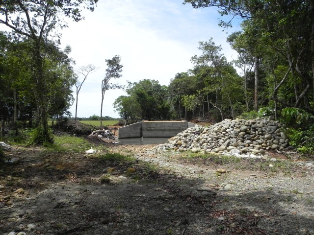
Forest affected by tertiary road improvements causing disruption of wildlife crossing in 2011 in the study area.
© Copyright Disclaimer. All pictures used on this web page are protected with copyrights to Xyomara Carretero-Pinzón. If you want to use any of these pictures, please leave a message on the website. Thank you.
